Tuesday, 26 June 2018

Walking through Carnarvon Gorge

For a long time I have heard of and been reading about what a great place Carnarvon Gorge National Park is to walk and hike through.  Now, being in the vicinity and with time to visit, we booked ourselves in for a 5 night stay.

Our campsite was a beauty sitting atop a sandstone ridge that afforded a 360 degree view of the area.  From this vantage point, seated in our camp chairs, in the morning we could watch the sunrise over the plains to our east while enjoying a coffee and then, with nothing more than a swivel of our chairs, we could observe the sunset behind the walls of the gorge to our west with a ‘sundowner’ in hand as the day came to a close!  This is the life!

View looking west from our camp chairs.
Picture a glass in hand as the sun goes down behind the ridgeline...life is good!

The park information brochure identified several short walks and some longer more adventurous hikes that could be undertaken.  We planned our time so that we did the shorter walks first with the more difficult and longer hikes to follow on later days.  The last day was reserved to simply rest and relax.

On the first day we did two of the short walks which covered a total distance of less than 2km.  These amounted to what was literally ‘a walk in the park’.  One walk took us through a grove of fan palms and cycads nestled within the walls of the entrance to the gorge and popped out at a cave containing some great examples of stencilled Aboriginal rock art.

Heather in a grove of palms and cycads within Carnarvon Gorge
Aboriginal rock art - Ochre stencils of hands, boomerangs and axes

The second walk of the day was really just a visit to a rock pool where we hoped to see some turtles or a platypus but there none to be seen while we were there.

The next day took us along the bank of a small creek where, after a couple of kilometres, the formed track ended and we proceeded carefully into a narrow side-gorge.  The gorge got progressively narrower, cooler and darker until, with outstretched arms, we could touch the walls on both sides!


The gorge got so narrow that we could touch the walls on both sides!

Later that day, after a light lunch, we completed a sedate stroll along a nature trail located near the park ranger station.  Once again we hoped to spot a platypus in the clear flowing waters of Carnarvon Creek.  Once again, unfortunately, we were unable to spy one of these elusive creatures.  Total distance covered was about 4.5km.

On day 3 we did the 6.4km hike to Boolimba Bluff.  This hike required us to scale the steep slope of one of the gorge walls to a lookout situated 200m above Carnarvon Creek.

The sign was right!  It was very steep and I needed to be supervised at all times!

Upon reaching the lookout we were rewarded with views of the gorge from above as well as getting to see more of the surrounding ranges.

We were rewarded with some great views from the lookout at Boolimba Bluff

Our walks and hikes over the first 3 days of our visit, while getting progressively longer, were not that taxing (I used to walk 7km going to work and back home each day).  These were mere 'warm-ups' compared to the hike that we completed on day 4!

Day 4: The Main Carnarvon Gorge Walking Track criss-crosses Carnarvon Creek about 20 times (which equates to more than 40 crossings as you have to come back) as it wends its way to its end point at Big Bend some 9.7km upstream.  The hiking guide recommends trekking all the way to the end of the trail at Big Bend and then visiting the sites as you return rather than visiting them as you reach them on the outbound leg so this is what we did.

It took us about 2.5 hours to reach Big Bend with each of us managing to get a boot full of creek water along the way at different creek crossings.  We decided to have an early lunch before commencing the return leg which was to include numerous diversions along side-tracks leading to narrow hidden gorges, fern and moss gardens and several Aboriginal rock art sites.

Each of the highlights at the ends of these off-shoots were special in their their own different ways and well worth the extra km to get into and back out again.  In the order that we came to them as we returned to our starting point, I will briefly describe each.

Cathedral Gorge is a large rock overhang that provided shelter to Aboriginal people for thousands of years and its walls are covered in images reflecting the culture of those that gathered here.

Large rock overhang at Cathedral Gorge was full of Aboriginal stencils and paintings

The ‘Art Gallery’ contains over 2,000 rock engravings, ochre stencils and free-hand paintings on a 62m long sandstone wall.  This is one of the places within the gorge the ‘secret women’s business’ was conducted.

More ochre stencils and paintings - this time from the 'Art Gallery'.

Ward’s Canyon was a short but steep climb from the main gorge track.  We passed a small waterfall on the way up into a narrow side-gorge that shelters one of the last groves of the world’s largest fern - the King Fern.

Large Tree Ferns and King Ferns could be found in Ward's Canyon

Getting to ‘The Amphitheatre’ required us to make a bit of a hike off of the main trail then climb a series of ladders in order to access the narrow gorge which opened out onto the floor of a 60m deep, fern filled chamber.  With high stone walls and a natural skylight high above, the atmosphere inside is awe-inspiring.  We took the time to sit and contemplate in the peace and quiet within.

It was necessary to climb these ladders to reach the narrow entrance to 'The Amphitheatre'
Ferns growing inside the Amphitheatre reaching for the light 60m above
Heather quietly contemplates her surroundings inside the Amphitheater
The last diversion from the trail took us to the ‘Moss Garden’.  Again, after a bit of a hike and climb, we arrived at a steep-sided, cool, fern-filled sandstone walled gorge.  A small waterfall cascaded into a shallow pool before the water trickled away downstream while more water drips constantly from the sandstone walls all around it.  This constant supply of water sustains a lush green carpet of mosses on its walls and ferns along the creekside.  It was a beautiful cool place to sit briefly and take a load off our now noticeably tiring legs.

'Selfie' from the Moss Garden
Heather & small waterfall in the Moss Garden
With all of the listed sites along the route now visited we wearily completed the hike back to our vehicle parked at the trailhead.  By the time we climbed into the ute 7 hours and 40 minutes after we had started, we had covered about 26km (34,700 steps) and our legs were feeling them all!  Despite our tiredness we were very happy to have made the effort and highly recommend that anyone that can include a visit to Carnarvon Gorge in their itinerary should do so.

Heather has made a couple of videos of our Carnarvon Gorge walks - these can be viewed on YouTube by clicking on the links provided below:


If you like the videos and would like to see similar movies relating to the activities WTF? - Where are The Farrows? get up to, please click ‘Subscribe’ when at Heather’s YouTube channel to receive a notification whenever she uploads a new movie.

As WTF? - Where are The Farrows? continue their odyssey northwards towards the Gulf of Carpentaria we will be sure to let you know about the significant, weird, wonderful and quirky things we encounter along the way.


Personal Footnote: It has been 7 years since you passed away but I am still missing you dad - Love Grant.

Wednesday, 20 June 2018

NSW Mid-North and Northern Coast

Having descended to the east coast from the mountains for the first time in our journey thus far we decided that instead of making and breaking camp every day or two we would set up a base-camp and put our nomadic wandering activities on hold for a week or so.
Being the ‘off-season’ as far as tourists are concerned, i.e.: NOT school holidays, NOT summer, NOT a public holiday long-weekend, NOT Easter or NOT Christmas (that is a pretty narrow window when you write down all of the 'exceptions'), NSW National Parks were promoting a ‘pay 2 stay 3’ deal.  Hot and cold running water, a camp kitchen and laundry facilities were just what we needed after several days in the bush so we ‘doubled-down’ and signed up to pay for 4 & stay for 6 nights at the Trial Bay Gaol campground.  It was perfect - our site was sheltered from the wind but had views looking out across Trial Bay while the resident kangaroos provided some close contact with nature as well as the entertainment with their antics or when they sparred with each other!

Our base-camp was located to the left of Trial Bay Gaol - nice view!

Resident campground kangaroo enjoying a scratch as Grant looks on

After taking care of domestic duties on day 1 we were free to explore the region via daily outings up and down the coastline.

To the south we visited the town of Port Macquarie that happened to be in the midst of its “Hello Koalas” festival.  More than 60 koala sculptures, all the same but each with a unique ‘paint-job’, are located across the town and surrounds.

Heather with a Koala Sculpture in Pt. Macquarie
Grant with one of the other 60 odd koala sculptures in town
In nearby Kempsey we came across the Slim Dusty Centre.  Slim Dusty passed away in 2003 but  is an Australian country music legend and the centre is a museum honouring their most famous son.

Out the front of the Slim Dusty Centre in Kempsey
One of Slim’s most well known songs is ‘Pub With No Beer’.  The song tells of the sorrow felt when, parched and thirsty, you arrive at a pub only to find it has no beer!  The Pub upon which the story was based is located in the hills not that far away in the tiny town of Taylor’s Arm so we decided to pay it a visit.
The 'Pub With No Beer' in Taylor's Arm was made famous by Slim Dusty 
Fortunately, when we were there they had beer so we had a drink to celebrate then went home.

Enjoying a beer at the Pub With No Beer.  How does that happen?
The town of Coffs Harbour is the major regional centre along this section of the coast with all of the facilities expected of a town with a population of ~70,000, but it was the ‘Big Banana’ located on the highway as you enter town that caught our eye.
Heather standing at left of the Big Banana in Coffs Harbour
Why a Banana?  Well, as you may have guessed, bananas are grown in the region.  We stopped, took a photo, had a Banana smoothie and moved on.
The coastline in this part of NSW is beautiful.  Waves continually rolling in from the Pacific Ocean to the east crashing into long white sand beaches and headlands make for great walking, fishing, surfing and sunrises.  One of the best known locations for all of the above is Byron Bay.  While there, we visited the lighthouse situated atop Cape Byron at the easternmost point of the Australian mainland where, it rightly claims to be ‘the first place in Australia to see the sun rise each morning’.

Heather at Cape Byron - the most easterly point of the Australia mainland
We were not there early enough for the sunrise but we did see shoals of fish being hunted by sharks, dolphins surfing the waves in towards the shore and humpback whales blowing and breaching as they make their annual migration northwards.  Not bad for just an hour of viewing from the lookout!


In total we spent 12 days in and around this stretch of the NSW coast and we enjoyed every bit of it but it was time for WTF? - Where are The Farrows?, like the whales, to resume our northward journey.  Next stop will be somewhere in the state of Queensland.  We don’t know where just yet but will fill you in when we next post. 

Tuesday, 12 June 2018

Waterless Waterfall Way

It has been a while since my last post from the Warrumbungles and it has been even longer since meaningful rain has fallen in the New South Wales hinterland (the mountains and hills inland from the coast) - hence the title of the post!

Before I proceed, a little bit of Australian geography is necessary to help set the scene:

Australia’s Great Dividing Range is a mountain range that runs parallel to almost the entire length of the continent’s eastern seaboard.  This ‘spine’ of mountains pretty much separates the coastal region from the interior and most of Australia’s population chooses to live between these ranges and the coast.  Apart from the great weather typically experienced along this coastal strip, the key reason for the higher population density is an abundance of the water necessary to support this many people.  The ranges intercept the moisture laden clouds that roll inland from the Pacific Ocean, forcing them to rise.  As they rise, they cool and subsequently drop their moisture as rain on the coastal side of mountains which makes it way back to the sea via numerous rivers and creeks.  Here endeth the lesson - now back to the story...

We had decided to head towards the mid-north NSW coastline from the interior via Tamworth (the Country Music Capital of Australia), and a driving route known as ‘The Waterfall Way’.

'Straw Hat Heather' and her Golden Guitar in Tamworth - Yeee-har!

With Heather having released her inner hillbilly in Tamworth (I am glad to report that she has now got that out of her system), we were excited to set-off down the Waterfall Way to see some of what the national parks brochure was spruiking.  It says:

“Explore the parks along the Great Escarpment and the Coastal Ranges on the eastern edge of the New England Tableland.  Watch cascading streams and waterfalls still shaping this dramatic mountainous landscape, as you travel along the Waterfall Way.”

First stop along the route was a place called Dangar Falls.  The gorges and canyons were indeed spectacular, however, the water was not there to fall.  We said to each other, “It must be magnificent after it has rained!”

Next was Wollomombi Falls.  Again, breathtaking cliff lines and plunging ravines cut by the forces of water but no water was at work when we were there.  We said to each other, “It must be magnificent after it has rained!”

A couple more kilometres down the road and we were at Chandler Falls.  For an accurate description of this beauty, see paragraph above.  Also, and you probably know the drill by now; we said to each other:  “It must be magnificent after it has rained!”

Given our lack of success viewing waterfalls thus far we decided that as our campsite for the night was quite close to a lookout from which you could see all the way across the foothills of the plateau and out to the coast some 60 km away, next morning we would get up, make ourselves a coffee and head to the lookout in time to watch the sunrise upon a brand new day.  While the falls may not have had any water falling over them we had more confidence that the sun would come up tomorrow and at least we could watch the sun rise!  As sure as day follows night, the sun did indeed rise - and right on schedule too!

Heather bathes in the orange glow of sunrise on a cold morning

Last of the listed major waterfalls along the route was Ebor Falls.  Our previous recent experience had us expecting more of the truly spectacular scenery (it really was spectacular), but no water.  Imagine our surprise when we arrived at the lookout and first heard and then actually saw water!  Not much but water falling over the falls nonetheless!  Below is a photo of Ebor Falls just to prove that you really can see water-falling along this route.

Ebor Falls - the only falls along the Waterfall Way to have water during our visit!

With the sun rising as it should and water falling once more we were satisfied that the normal order of things had been restored so it was time for WTF? - Where are The Farrows?, to move on.  Next up, we take in some of what the mid-north and northern NSW coastline has to offer.

Monday, 28 May 2018

The Warrumbungles

We decided to stay for a couple of nights in the Warrumbungle National Park near Coonabarabran (described as "The Astronomy Capital of Australia"), in central NSW.  Two main reasons: Firstly, to allow us to do some star-gazing through telescopes at a local observatory by night, and secondly, to do some hiking and bush walking through the picturesque landscape by day.

With the weather forecast indicating a cold but clear night was expected we booked our places for some professionally guided night-sky & telescope viewing at a privately owned observatory.  The observatory being ‘private’, rather than a government funded research institution, means they typically make their money through doing their own research and by ‘selling’ telescope access time to scientists, astronomers and enthusiasts from around the globe.  They supplement this by conducting viewing tours for tourists like us.  While we were there we could periodically hear the whirring of one of the 'telescopes for hire' being repositioned by the renter who, in this case, was located elsewhere in the world and was controlling the telescope via the internet.

Numerous 'telescopes for hire' at a privately owned observatory

The ‘tour’ included an astronomy presentation followed by our fully qualified host pointing out various stars, planets and constellations using the naked eye then through 3 different telescopes.  We managed to get a look at Jupiter and Saturn along with a number of star clusters, distant nebulae and galaxies.  It was a very enjoyable and informative experience!

The following morning, we embarked upon the longest and most strenuous hike thus far in the WTF? - Where are The Farrows? era.  The ‘Grand High Tops via Breadknife Circuit’ is 14.5km in length and took us through the national park along creek beds, up gentle and then steep climbs to to lookouts near the top of the range and back down again.

We set out around 9am and hiked steadily with pauses only to appreciate the spectacular views that were revealed around almost every turn in the trail. A brief but welcomed 15 minute picnic lunch stop was all too quickly over then back down into the valley we went.  After 5 hours we were both feeling a little foot and leg weary but we had completed the loop!

Our hike in The Warrumbungles revealed many spectacular vistas

Part of the way up!

Didn't matter which way we looked it was always impressive!

A hot shower upon return to camp was a great way to relax after the hike.  We did not stay up too long looking at the stars that night and were pretty much asleep as soon as our heads hit our pillows!

We really enjoyed our visit to the Warrumbungles and, as it turned out, it neatly wrapped up the ‘Space’ theme that our travels had taken a few days back starting with our visit to the Parkes Radio Telescope.


WTF? - Where are The Farrows?, will continue as we wend our way down the highways and byways of eastern Australia.  “Which way now?”, you ask.  “The Waterfall Way” is the answer.

Friday, 25 May 2018

Virtual Solar System Drive

After watching a beautiful misty sunrise at our latest camp on the banks of the Macquarie River it was an easy 35km drive into the regional centre of Dubbo to re-supply and gather information to help us decide “What & Where to next?”.

Morning mist burning off as the sun rises over camp

As soon as we got out of the car at the Dubbo Information centre we had our answer, not just regarding “What & Where?”, but also “What route to take?”.

We decided to do "The World's Largest Virtual Solar System Drive" 

Billed as “The World’s Largest Virtual Solar System Drive”, the road trip to the Siding Spring Observatory, (a 37m diameter dome housing the 3.9m diameter Australian-Anglo Telescope), perched atop a mountain in the Warrumbungle Range, is a scaled (1:38 million) model of our Solar System.


Our route would take us to the Sun at Siding Spring Observatory from Pluto in Dubbo (starting at lower left)

The 37m diameter dome represents the Sun (actual diameter of 1.39 million km).

The Australian-Anglo Telescope is housed within the 37m diameter dome

Starting at the outer reaches of our solar system, Pluto, at this scale, is about half the size of a billiard ball and is located a mere 190 km down the highway (in Dubbo), from the Observatory (vs. 7.2 billion km in reality).  As you drive towards the Sun each of the planets are represented by billboards placed in roadside turn-outs located the appropriate distance from the Sun/Observatory along the route.

Road distances (in km) of each planet to the Sun along our route from Dubbo

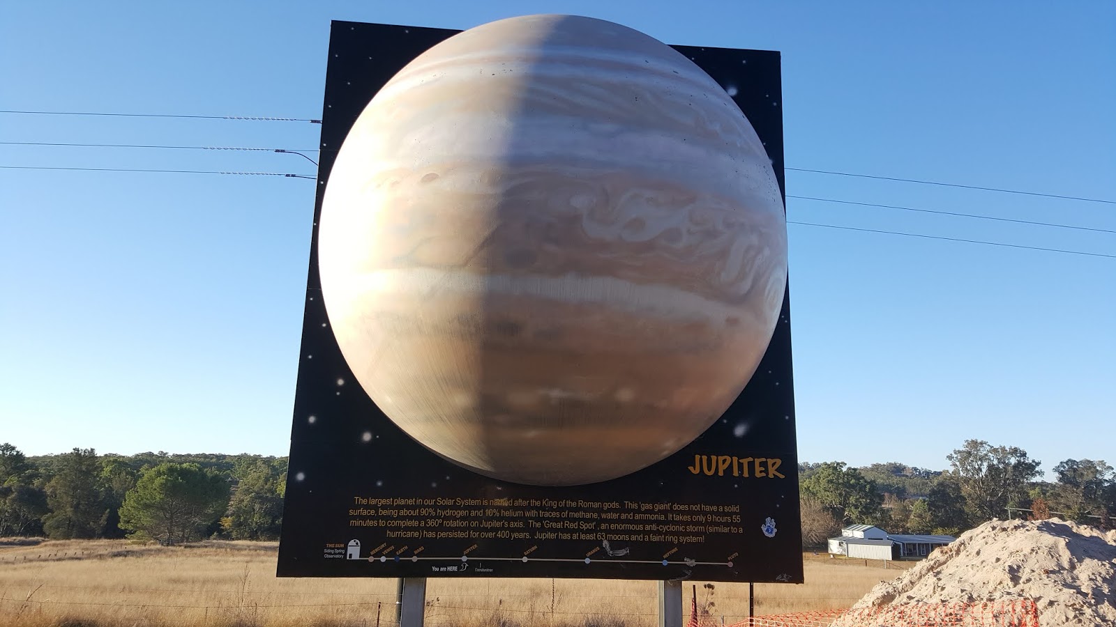
We stopped at each of the billboards containing information and a scale model of each planet and learned a bit about them all.  At scale, Jupiter, the largest planet in our Solar System is ~ 3.9m in diameter and 22 km from the sun (~800 million km).

Billboard with 3.9m diameter scale model of the planet Jupiter

At the end of a fun and informative drive to the Sun we toured the dome housing the big telescope.  As it happened we were lucky enough to be in the observation room to see both the dome and telescope being repositioned for its scientific star-gazing to be done later that night.

'Selfie' from Inside the dome as the telescope was being repositioned

The cool/cold clear night skies and light-pollution free conditions present in the elevated Warrumbungle region in central NSW make it the perfect place for star-gazing.  For these reasons the Siding Spring Observatory was built here in the1960s.  The observatory is a working research facility so, unfortunately, the public has no access to the 45 telescopes that are located here.  To get a closer view of the universe you have to visit one of several private observatories located in the area.

The vista of the Warrumbungle region from the mountain upon which the observatory sits was enough for us to decide to stay in the nearby National Park for a couple of days to do some of the hiking trails.

View of some peaks within Warrumbungle National Park from the Observatory

It is hard to do justice to the scenic beauty of the park with words alone - as a result of this, in the next edition of WTF? - Where are The Farrows?, I will give the pen a bit of a rest and be heavier on the pictures.

Tuesday, 22 May 2018

Lap of the Mountain

Ever since I was a small boy I have enjoyed watching Australia’s premier motor racing event, ‘The Bathurst 1000’, held each October at the Mt. Panorama circuit near the town of Bathurst.  When the route we were travelling had us driving right by the entrance to the public road / racetrack, I couldn’t NOT do a lap while I was this close!  With a flick of the indicator I turned off of the highway and took the ute/caravan combination onto the Start/Finish straight for the start of my strictly enforced 60 kph lap of the track.

As the name of the circuit suggests, Mt. Panorama is indeed a mountain.  Starting at the base you climb steeply up one side of the mountain before twisting and turning your way across the top where, if you are a passenger, there are apparently some quite ‘panoramic’ views to be had.  As the driver you can’t look or relax as just as soon as you are at the top, it is more twists and turns as you descend steeply down the other side.  Only when on a long straightaway can you loosen your grip on the wheel!

View of the track through the drivers' eyes

Even at just 60 kph with its blind corners and steep dipping bends, the track is challenging, especially when dragging a 3t caravan behind you.  It took us about 7 minutes to get around.  I now fully recognise the skills (and lunacy) of the race car drivers who hurtle themselves and their machines around here on race day in just over 2 minutes per lap at speeds approaching 300 kph!

With that boyhood dream now behind me it was time to get to our campsite before the weather we had been running from caught up with us.  Upon arrival at the location we had picked, situated halfway between Bathurst and Orange, we were a bit disappointed to find it much less sheltered than we had been hoping for but with the weather and darkness approaching we did not have time to find anything else.  We quickly set-up and hunkered down for what turned out to be three days and nights of very strong cold winds and driving rain with the odd snow flurry thrown in to boot!

Not unusual in Canada but in Australia... WTF is going on?

Too miserable to be out and about on foot and feeling too cooped up to stay in the caravan all day we made the most of a poor situation and did a couple of self-guided extended driving tours of the region.

On day one, we drove about 100 km to the east to Katoomba in the Blue Mountains to see ‘The Three Sisters’.  While the sky was clear in Katoomba and the view well worthwhile, we nearly got blown off the side of the walking trails.

The Three Sisters from Echo Point Lookout in Katoomba, Blue Mountains NSW

On day two, we travelled about 100 km to the west to visit the town of Parkes (home of the annual ‘Elvis Festival’), and the nearby Parkes Radio Telescope.  While we didn’t see Elvis (the festival is held in January not May when we were there), we did get to visit ‘The Dish’.

The Parkes Radio Telescope received and relayed the live TV images of man stepping onto the moon.

The Parkes Radio Telescope was responsible for capturing the live Apollo 11 moon walk TV signals that were beamed to Earth from the moon and then relaying them around the world for public broadcast to the millions of people sitting in front of their TVs to watch the event.

With Heather at the controls of 'The Dish', what could possibly go wrong?

We left the Snowy River Country in order to avoid the worst of a big weather system that was forecast.  That region might have gotten 60cm of snow dropped on them but I am almost certain it was just as cold where we were - it sure felt like it and I think I may have said something like WTF? (and I was not asking Where are The Farrows?).


Keep your antenna searching the ether for the next WTF? - Where are The Farrows?, where the interplanetary cosmic theme that started in Parkes, continues…

Saturday, 19 May 2018

Almost a Nice Shower

We pulled out of Snowy River Country through a light but clearing fog.  The forecast wild weather was not due for a few more hours so we still had good conditions for driving, albeit a bit frosty at the outset.

We turned north and westerly to put some distance between us and the high country in order to stay out of reach of the snow storm.  After a couple of hours on the road in lovely sunny conditions we decided to stop for lunch at a bush pub that we came across enroute to our next stopover.

At this stage I must let you know the following so that you don't think of us as being dirty or strange (or both?):  In order to attract clientele to their establishments, many small town pubs in Australia offer a free hot shower to travellers in exchange for buying a drink and/or a meal in their establishment.  Being 'clean again', holds some considerable appeal to travellers who, like us, may have been 'free camping' for a while and have had limited access to hot and cold running water, other than what they can carry in their caravans or motorhomes, sufficient to really wash the smell of smoke from campfires and grime of camping off of themselves.


The Beehive Hotel in Coolac, NSW.  Showers with running water - Optional!

We went in and asked the proprietor of the empty bar if the offer of a shower with a meal was still good.


"No problem.", he said.
"There is plenty of hot water.  The shower is out the back - go ahead."

We placed our order for lunch and as I am a gentleman, said to Heather;


"Ladies first."

Heather got her kit and went to take a shower.

I did a walk-around our rig to do some basic checks to kill some time and got my shower kit ready.  It was going to be really good to have a hot shower instead of a 'bird-bath'.

At the same time as Heather emerged from the shower room, I heard the publican's wife yell out to her husband, saying:


"The power just went off."

Heather, who didn't hear this said to me;


"The pressure isn't that high, it was a bit dark in there and the exhaust fan just shut-off but the shower was nice and hot."

I told her about the power going off and as I was so eager to clean myself up a bit, I marched right in perfectly OK with the prospect of showering in the dark without an exhaust fan.

I stripped off, turned on the taps and stepped under a weak flow of water.  I thought the water might cool off quickly without any electricity so I got straight to wetting and washing my hair to get the smoke out of it.  I was pretty much done in just a minute or so when the water flow diminished to a trickle.  Oh-oh!  I directed every last dribble that fell onto me at the remaining soapy bits and luckily, by the time even the drips stopped, I was done!

As it turns out, the hotel uses bore water which is delivered using their electric pump.  No power, no pump, no water.  The water in my shower was what was left in the pipes from the upstairs accommodation section of the pub!

We ate our lunch, thanked the publican and his wife for the food, the shower (and the almost shower) then hit the road again.

In the next report, a clean WTF?- Where are The Farrows?, will describe what it was like towing a 3.5 tonne caravan with a diesel ute around Mt. Panorama, Australia's most famous motor racing circuit.  It is a steep, tight and twisting track to say the least!