Saturday, 21 October 2017

Silverton

The town of Silverton was established early in the 1880’s on the back of prospectors seeking their fortunes from mining claims they had staked in the district.

Mining, Ore Tramway and Movie history reflected in the 'Silverton' sign.
In 1883 the name of the town was proclaimed and a post office was built.  The population boomed from 250 up to 3000 within two years.  With the growth in population came the typical list of supporting businesses and services (both necessary and parasitic) that go hand in hand with mining town development.  These included doctors, law (police) and order (solicitors and judges), power-brokers (local politicians), newspapers, hotels, religion and all manner of entrepreneurs looking to make a buck in the thriving mining town.

Unfortunately for Silverton’s longer term growth, in 1885 and just 25km away in Broken Hill, the discovery of silver, lead and zinc deposits (which subsequently proved to be the largest in the world) meant that Silverton’s population had already peaked.  People moved to Broken Hill and the town started to decline just a few short years after being established.  With a general shortage of building materials available in the greater Broken Hill area, many of Silverton’s buildings were dismantled and transported to Broken Hill and rebuilt there. 

While the miners are long gone a few significant historic buildings still remain, and just 40 people currently live in Silverton but it appears to have found a new lease of life.  With its clear blue skies, ‘Outback Red’ landscapes and classic 1800’s stone buildings, the location has attracted filmmakers from afar.  Since about 1980 the town has hosted dozens of movie and TV productions.  These include Mad Max 2, and Priscilla Queen of the Desert, amongst others.

The Silverton Hotel seems to feature in just about everything that happens here from movies through to where a visitor will eat when they are in town.
At lunchtime there were more people inside than live in the town!
The pub attracts everyone and on the day we were here there was more than the town population inside having lunch.  Not bad for a ghost town!

Of the 40 residents here, there are a number of artists.  In our travels along the Darling River we came upon the work of Lightning Ridge artist John Murray, who proved to have a bit of a thing for Emus (remember the sculpture of Stanley the Emu, and other cartoon like paintings with Emus featuring strongly).  In Silverton one of the local artists ‘in residence’ is Howard Steer who has quite the strong sense of ‘bush humour’ and appears to have a thing for the Flying Doctor – not the Royal Flying Doctor Service (RFDS), which he no doubt strongly supports, but a ‘Flying Doctor’ complete with medical bag and his own pair of wings, that he includes in almost every painting he does.  An example of what I am talking about can be seen in the photo of a painting that he did on the side of a broken down old car that is positioned at the entrance to his gallery in Silverton.  The painting is called 'Flying Doctor's New Website'.  If you click on the image to enlarge you will see a couple of spider webs in the branches of the trees.  That's bush humour for you.

Flying Doctor's New Website - Painting on car door at entrance to gallery

For more examples of his work you can click on the link provided at the bottom of this blog.
With that I shall sign off for this episode of WTF? – Where are The Farrows? and will also conclude this 'Darling River Run' series as we will arrive back home in the next day or so.  I hope you have enjoyed the posts and that the style of writing has not become boring.  Until our next adventure, please take care of yourselves and the ones you love.
http://www.howardsteerart.com.au/gallery.php

Friday, 20 October 2017

Broken Hill

As well as being directly on our route home, the town of Broken Hill is the ‘birthplace’ of my one and only employer (The Broken Hill Proprietary Co. Ltd or ‘BHP’) since I was 17 years old.  BHP was formed 132 years ago in 1885 and has since grown and spread across the globe to be, at the time of writing, the largest diversified mining house in the world. 

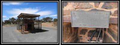
Having never stopped in Broken Hill to look around we went straight to the tourist information centre and grabbed some brochures describing a range of ‘Things to Do’ while in the neighbourhood.  We opted to do a self-drive tour of the town.  A ‘Point of Interest’ included in the tour was the site of the first BHP Office ever established which we duly visited.  Not much left anymore except for ruins of part of the fireplace chimney and a brass plaque saying who built it and when.  Don't know what I was expecting but it was something more than this...

All that remains of BHP's first office is chimney ruins and a small brass plaque

Feel free to Click to enlarge pic if you wish to read and get a few more details

With my pilgrimage to the birthplace of the ‘mothership’ now underwhelmingly complete we continued our explorations of the town which included plenty of mining history and monuments, the art galleries of some of the more well-known artists that call or called Broken Hill home, e.g.: Pro Hart, Jack Absalom, etc..  Also part of the tour was a visit to the Living Desert Reserve and the Sculpture Site that is within it.

Several sandstone sculptures on top of a hill in the Living Desert Reserve
 
12 sandstone sculptures were installed as part of a sculpture symposium held on the hilltop in 1993 by artists from around the world.  As with most art, some pieces made more sense or resonated better with me than others.  Being totally honest I must confess that a couple of them (maybe more than a couple) still just looked like blocks of stone standing on a hilltop - which is exactly what they are.  Score one point for logic, but zero for artistic interpretation!
After a few hours of driving around becoming geographically, historically and culturally aware we returned to our ‘campsite’ for the day which was actually a parking spot in front of the grandstand of the Broken Hill racecourse.  It turned out to be very nice, having green grass underfoot (not much of that to be found in Broken Hill), and sharing a drink and some nibbles with a couple of our neighbours of the day before turning in for the night.

Not the bush camp setting we were used to but the green grass was a nice change

In the morning we were woken by the sound of hooves and the snorting of horses in training during the cool just before dawn.  Now awake, I decided to get up and watch them pace around the dirt track and managed to snap a nice photo of the finishing post with the rising sun right behind it.


Mining Headframes form part of the Finishing Post at Broken Hill Racecourse

 
With our next overnight stop not very far away we enjoyed a leisurely coffee before hitching up the caravan once more and moving on.

The next episode of WTF? – Where are The Farrows? see us in the busiest ghost town (and location for quite a few movies) we have come across yet!

Thursday, 19 October 2017

Cobar and Warrawong on the Darling (near Wilcannia)

It was when we pulled out of Gulargambone that we really commenced our journey westward towards home back in Adelaide.  Almost all of the remaining 1,300 kilometres across NSW and SA would be on the Barrier Highway.

Rather than make a mad dash home we took a more leisurely approach and spread the journey over 6 days and 5 nights.  In this blog I will describe the first two days and nights.

First overnight stop was at a pleasant free camp site called Newey Reserve in the town of Cobar.  Cobar is home to about 5,000 people but as it was a Sunday when we rolled into town, it was very quiet and seemed much smaller.  The town was established to support mining and pastoral activities in the area.  That mining has been and still is a big part of the town’s economy is obvious as soon as you approach the town from the east.  A mining scene adorned with very large letters spelling out COBAR makes it clear that you have arrived in a mining town.

Just in case you don't know where you are - Welcome to COBAR!

After securing a position for the caravan on the shore of the Newey Reservoir we drove about town to what there was to see and stopped at the grocery store in town for some supplies (and to support the local economy in appreciation for the free camp sites provided), then it was back to camp for a leisurely Sunday afternoon.

The following morning we hit the road again and drove about 260 kilometres further west to a caravan park called ‘Warrawong on the Darling’, just a kilometre out of the town of Wilcannia.  The place has powered and unpowered sites as well as 'bush camping' sites further out on the property.  We chose a bush camping site on the bank of a nearby billabong as our patch of ground for the night.
 
Nothing like a seat beside the campfire as the sun goes down!

After setting up for the day and night, which comprised nothing more than parking on a level piece of ground, un-hitching the caravan from the ute and switching it to gas and solar power, we took a drive on some of the property roads to check out a very large and very old River Red Gum tree on the bank of the Darling River.
 
‘Big Red’ as it had been dubbed is over 11m in circumference and has been determined to be about 500 years old.  Heather, ever alert for a metal detecting opportunity with real potential, promptly got her metal detector out of the truck upon arrival and took a quick swing around the base of the giant. 

Heather was dwarfed by 'Big Red' as she searched for lost treasures!

At over 500 years old and 11m around the base Big Red is a mighty tree!

The 'opportunity with real potential', for those that don't know what I am talking about, arises from the fact that big old trees along the banks of rivers were often used as shady resting spots or campsites by passers-by.  Whenever they sat down and/or got up from a fallen branch or root beneath the tree, often was the case that a coin would fall out of their trouser pocket (same thing today when you sit down or get up off of the couch)!  An old silver sixpence or shilling or maybe even a gold sovereign is what Heather was hoping to find.  Unfortunately, Big Red was giving up nothing from her past that day and Heather returned to camp empty handed.
 
Although other campers and caravanners had made a similar choice to set themselves up on the edge of the billabong, it was a large waterhole so our nearest neighbour was at least 200m away.  With that sort of separation we were able to enjoy the serenity of the bush and enjoy a 'Sundowner' while watching the pelicans hunt for their evening meal.  As the sun dipped further below the western horizon the light from our campfire became ever brighter.  Not long after that the stars came out to play... in case you hadn't guessed by now, we really like camping out in the bush!
 
 
Watching the pelicans out fishing in the billabong at sunset

When I next put pen to paper (so to speak), we will likely be within a day’s drive of home.  Stand-by to read all about what we come across as our WTF? – Where are The Farrows? Darling River Run adventure draws closer to its conclusion.

Wednesday, 18 October 2017

Gulargambone, NSW

We first heard of Gulargambone only a couple of weeks prior during our ‘Poetry on a Plate’ dinner and show while we were staying in Bourke.  The poet described how the Gulargambone locals had shown great resolve to prevent their town from the continual decline that results from rural downturn and young folks moving away from family farms and into the cities.  He said the town was a great example of how ‘from small things, larger things grow’.  As a result of his story we decided to turn off the highway to check the place out and maybe stay for a night!

Firstly, the town name: Gulargambone.  3 syllables pronounced, 'Gular-gam-bone'.  It is derived from the Anglicised corruption of an aboriginal word “gilagambuwan” which means ‘Place of Galahs’.  For those unfamiliar with them, a Galah is a grey, pink and white parrot – see pic below.
The 'Galah' - a medium sized grey, pink and white member of the parrot family.
 
Gulargambone is a small rural town (pop ~ 300) which was established circa 1840 on the Castlereagh River.  The surrounding area is farming and grazing land.  Like most small country towns it has experienced shrinking population and services over the years as it has become ever easier to drive into nearby larger centres.

Community Spirit!

In 2000, when it appeared that the local Post Office was to be shutdown, rather than let this happen the townsfolk banded together to form the GRTC (Gulargambone Rural Transaction Centre) and took over the running of the post office with great success!  Off of the back of this success, in 2002 the community purchased the old Majestic Theatre building and turned it into a multi-purpose volunteer run Visitor Information Centre, café, Gallery and Craft Shop.  The place is known as the Two Eight Two Eight Café (after the town’s Post Code of 2828).  This has now become the focus of the town’s social life.

The mosaic tiled entry to the 2828 Café in Gulargambone
 
Lastly, the town developed a concept whereby they would place corrugated iron sculptures of galahs throughout the town and along the approach roads into the town.  Each sculpture is about 2 metres square and positioned 2-3 metres above the ground on metal poles.  All up there are 40 galah sculptures so far.  Creatively, some involve ‘flocks’ of 2, 3 or 4 galahs positioned as road markers indicating you are 2, 3 or 4 km from the town! 
 

Corrugated Iron Galah in town
 
This pair indicating you are about 2 km from Gulargambone
 
Keep flying in this direction - You are just 3 km from Gulargambone!
WTF? – Where are The Farrows? never expected to find themselves in Gulargambone but we are glad we did!  Nice work Gulargambone, and well done to Andrew Hull, the Bush Poet in Bourke, that made us aware of the resilience and effort that people proud of their communities will go to in order to halt their decline.

Tuesday, 17 October 2017

Mungindi and The One Ton Post

After a week or so spent along the lower Fraser Coast, including Hervey Bay, Tin Can Bay and Rainbow Beach and then the Sunshine Coast where we based ourselves in the Noosa area it was, unfortunately, time to commence the return leg of our road trip.

From the Sunshine Coast we made our way to Toowoomba where during an over-night stop we managed to catch up with my cousin Scott.  After a bit of head scratching we determined that it had been about 26 years since the two of us had last seen each other!  We spent a very pleasant evening reacquainting ourselves over a couple of beers and a barbeque.

' Selfie' of Grant, Scott and Heather - We got together when we passed through Toowoomba

Our last night in Queensland was spent at a free campsite on the northern bank of the Barwon River at Mungindi.

Heather relaxing in the shade of the van alongside the Barwon River

Mungindi is a border town which lies on both sides of the QLD and NSW border.  It is unique in that it is the only town in Australia where the name is the same on both sides of the border (but both sides share a single NSW post code - 2406).  Strangely for a town with a population of just 700, and no signs of crime in the town, it has two police stations – one staffed by QLD Police, the other with NSW Police, located on either side of the bridge!  Also strange is the fact that during the summer months when daylight saving time is in effect in New South Wales but not in Queensland, Mungindi operates on two different time zones.  Odd but true!
Mungindi’s main claim to fame, however, is the ‘One Ton Post’ which is located about 8km west of town.  The marker is the original survey peg placed by surveyor John Cameron in 1881 and marks the eastern end of the border between NSW and QLD that runs for 700km along the 29th parallel.  East of the One Ton Post the border between the two states meanders with the river (or rivers) to the Pacific coast (see map on One Ton Post sign in pics below).

NSW (south) side of the One Ton Post

View from QLD (north) side of the One Ton Post

Click to enlarge and you can read all about it yourself!

The next post of WTF? – Where are The Farrows? will be from somewhere south of the QLD border.  Exactly where even I don’t know!

Sunday, 15 October 2017

Heather sets foot back in Queensland

As we approached the New South Wales/Queensland border we worked out that it had been 9 years and 83 days since Heather had left Townsville, QLD as part of our move back to Canada in 2008.  With that in mind it was a no-brainer to stop for a photo at the border sign to commemorate her setting foot once again in the state she called home for 4 years.

Queensland is renowned for its abundant sunshine and warm weather and we have often joked that the ‘Queensland State Dress Code’ is ‘sunglasses, shorts, singlet or t-shirt and thongs’.  You will note that in the photo below, Heather is fully compliant as far as the dress code is concerned!

Heather in full Queensland Dress uniform!  Sunnies, shorts, singlet and thongs!

Our re-entry into Queensland took us through the towns of Hebel (stopped to stretch the legs and check the car & caravan, Dirranbandi (where we stopped at the local bakery for lunch and saw an interesting and 'trip-relevant' memorial for the Australian Horse Regiment), St George (to restock the beer fridge), and our stop for the night in the free camping area along the Moonie River across from the Nindigully Pub.

Memorial to the Australian Horse Regiment in the town of Dirranbandi
Australian Horse hat badge found by Heather earlier in our trip
The charging horse regiment memorial was a nice link to the Australian Horse hat badge that Heather had found metal detecting along the banks of the Darling River earlier in our trip.  The badge would have been pinned to the left side of the hat (click on the photo of the memorial to enlarge and look at the hat - the pin probably would have helped hold the ornamental hat feathers in place).
Nindigully Pub at Sunset - a real bush pub.

We had a beautiful free campsite across from the Nindigully Pub and dinner inside it.  This place serves two of the biggest hamburgers you can buy anywhere!  The ‘small’ burger which is on the daily menu weighs in at 5kg (11lb) and cost $60!  We saw a couple of these served up – each one fed a group of 6.  The ‘large’ burger weighs 25kg and is a special order that has to be placed well ahead of time – I imagine football teams on their end of year trip might be the only groups realistically capable of finishing one of these off!  We each chose a more modest meal for ourselves after listening to an impromptu recitation of some bush poetry by one of the locals that had clearly enjoyed his afternoon at the bar!  It was all good fun.
What a way to spend our first night back in Queensland!  To learn WTF? – Where are The Farrows? on day two in Queensland, you will have to wait for my next post so continue to watch out for your email notification.

Saturday, 14 October 2017

Lightning Ridge

Since commencing our Darling River Run we had towed the caravan over more than 600km of dusty and at times corrugated dirt roads. Following our visit to Grawin and the NSW Opal Fields we were at the end of our predominantly dirt road travels for a while and everything - us, the car and the caravan included, were all in need of a good wash down.

A quick look at the map showed that only 75km away was the town of Lightning Ridge which just happens to have a public Artesian Bore Bath!  Nothing like a relaxing hot tub to soak in and really wash off some of the accumulated dirt.  As soon as we saw the bore baths were located just a couple of hundred metres from a caravan park we decided we were off to Lightning Ridge!

Lightning Ridge is the unofficial ‘capital’ of the Opal Fields and has all of the services to be expected in a small town (fuel, groceries, post office, etc.).  The town is also the home to a well-known and successful local artist (paintings and sculpture), John Murray.  You may recall a couple of humorous pictures from previous posts (bouncing car towing caravan over rough roads, emu’s eye view of oncoming car & caravan).  I like them so have included them again in this post (see below).
We thought of ourselves when we saw this picture

Once again - thinking of our own journey and our Emu near miss when we saw this picture

One of his larger creations is an 18m (60ft) high sculpture of an emu named ‘Stanley’ that unexpectedly greeted us on the highway 11km out of town.

Heather standing beneath 'Stanley'
Stanley has structural steel columns for his legs and neck, a body made from a rusted old Volkswagen Beetle and his head is comprised of a VW Beetle hood for a beak and two old satellite dishes for eyes!  We had come across plenty of emus on and alongside the road during our journey but Stanley was definitely the biggest.  At least he wasn’t going to run across the road in front of us!


The town of Lightning Ridge is working hard to entertain tourists that visit the place with 4 ‘Car Door Tours’ that you can self-drive.  These are known as the ‘Green’, ‘Red’, ‘Yellow’ and ‘Blue’ Car Door Tours.  Get a map from the tourist information centre and then follow each of the different routes which are clearly marked using car doors painted in the appropriate colour strategically placed along the way.  It is an easy way to see the various points of interest and unique attractions in and around the town.

Our day concluded with a long-awaited visit to the Artesian Bore Bath as the sun was going down.  It is a large pool that has been established for public use and has a natural hot artesian water flow directed to and through it.  The water temperature does not vary much throughout the year ranging from a low of 39°C up to 41°C which is just like the water temperature in a bath you would draw at home.  While the water is clear it does have a bit of a sulphur/mineralised smell about it.  We chose to consider that to be a 'positive' thing, namely, 'complementary natural bath salts’.  The soak in the naturally hot water was just what we had been hoping for and went back to camp that night feeling thoroughly clean and relaxed.

Relaxing in the hot artesian bath at the end of the day!

In the next episode of WTF? – Where are the Farrows?, Heather returns to Queensland for the first time since we left it over 9 years ago!

Friday, 13 October 2017

NSW Opal Fields near The Grawin

To say that the communities and the people that live in them in the Grawin opal mining area near Lightning Ridge in NSW are unique is quite an understatement!

Hot, dry and dusty is a good summary of both the climate and the working conditions.  It is a dry heat with dust either hanging in the air or settling on everything else.  It is a ‘hard to stay clean’ kind of environment.  The dirt in the surrounding area is red but just below the surface in the opal fields themselves, it is chalky white.  The place is covered in holes and shafts with the heaps of waste rock, called ‘mullock’ that came out of them piled right nearby.  It is like giant wombats or gophers have been allowed to dig unchecked for years!  Opal was first discovered out here in 1905 and after more than 100 years of digging, ‘pock-marked moonscape’ is a pretty accurate way to describe the landscape.
Holes, shafts, diggings and mullock heaps everywhere you look!

I am guessing that not too many folks get rich quickly (some might have gotten lucky but not many), but most that live and try to make a living of it have certainly got a good dose of ‘opal fever’, where a small ‘trace’ or ‘flash of colour’ can be enough to keep you there ‘just a little bit longer’ in the hope of striking it rich.  We did a little fossicking or “noodling” amongst the waste dumps but didn’t find any colour – a couple of plain and dull pieces but nothing flashy enough for us to catch the fever.
Found some very poor quality opal samples on a roadside waste heap!

Plenty of the characters we came across look like they have been there for years – real ‘Bushies’.  I don't think the shaving kit salesman bothered to come out this way much, or if he did, he did a really poor sales job - some of the beards we saw would put Santa Claus to shame!  Anyway, there are three places, other than working on their claim blocks, where you are sure to see the locals – all of these places sell beer, while two of the three also serve food.

The first of these establishments we came across is called ‘The Club in the Scrub’.  It probably started out as a corrugated iron shed but has grown in a ramshackle manner to now be an official ‘members only’ clubhouse alongside the local golf course.
Plenty of 'Bushy Beards' seen in here!

Grant at The Club In The Scrub bar (note: Bushy Beard in background)

The second place is known as the ‘Glengarry Hilton’.  It is comprised of a bar and a separate containerised kitchen from which the locals and visitors can buy a counter meal.  We parked the caravan out the back of the Hilton for the night – the price for doing so was simply to buy something, anything, from the pub.  This also entitled you to also use the attached toilet facilities.  So, in order to cover our obligation, we had dinner and a drink there later that night.


We parked out the back of the 'Glengarry Hilton'.  No valet parking service here!

Heather at the Hilton's 'Opal bar' (Another Bushy Beard was just to the left of shot)

Last in the order we got to them but not least, was the Sheepyard Inn.  Drinks (of course!)and basic groceries were available but they had not been serving food there for the past few days.

Heather at the Sheepyard Inn (note: Bushy Beard at right)

We also came across one of those oddities you sometimes (often?) find in the bush out the back of the Sheepyard Inn.  It is not that unusual to find a 'Shoe Tree' where people have thrown or hung a pair of shoes on the branches of a tree, which over time many other people do too.  However, this time it was a 'Bra Tree'.  There are not too many women out here so not really sure where the all of the adornments came from...who knows?  'Don't ask - Don't tell' is probably the best approach to take with this one!

'Bra Tree'.  Maybe a lonely miner is trying to grow some boobs?
After an enjoyable day and night in the dry opal fields of NSW, we needed to wash some dust off of ourselves.  Stay tuned to discover WTF? – Where are The Farrows?, and where they find a hot bath to clean themselves up in!

Thursday, 12 October 2017

Out the Back O'Bourke


After bidding farewell to the feral goats that we shared our lovely free camp with in the village of Louth, we hit the road early and given it was just a short 100km to Bourke, we arrived before most folks had checked out!  They are pretty laid-back folks out in the bush so they had no problem with just letting us find a site that we liked and to come back and let them know which one we had set up on.

As luck would have it, we were there on an evening that a local bush poet puts on his ‘Poetry on a Plate’ show so we booked ourselves in for dinner and a show that evening and then set out on our touristing way.

Bourke has a lot of history due to it being the hub of outback NSW farming, mainly sheep and wool, from the mid 1800’s through to about WW1.  The Darling River was the lifeblood and transportation link to the rest of the country and Bourke was the major port at the head of the river.  The wool and meat from sheep was sent down river to markets on barges towed by paddle steamers.  The paddle steamers would stop in at all of the big stations along the length of the Darling but for the rest of the runs (or stations) that did not have river frontage or were further out the ‘Back O’Bourke’, they typically had to haul their production into Bourke using bullock trains.  The bullock trains have since been replaced by Road Trains (giant semi-trailer trucks) and the paddle steamers and barges were put out of business by droughts and the arrival of the railway.
 
Former working Paddle Steamer 'Jandra' now does tourist cruises

All of the history of the region and stories specific to strong and unique characters that helped build, define, describe or find infamy out here are well described at the ‘Back O’Bourke’ Exhibition Centre.

Entrance to the Back O'Bourke Exhibition Centre

It is a tough life out here with the heat, dust, isolation and frequent droughts that can send a farmer to ruin.  This was particularly the case during the late 1800’s when the place was being built from nothing.  A famous journalist and poet of the time, Henry Lawson, was sent out here from Sydney by his editor to ‘dry out’.  The experience certainly left its mark on him as much of his best known and regarded work relates to his time spent in the Bourke area and surrounds.  He is famous for having said, “If you know Bourke, then you know Australia”.  The folks that live around here are quite proud of that.


After a couple of days here, Heather and I think we now know a little bit more about Bourke.  By Henry’s definition, we should also know a little more about Australia – and I think he is right.

Next time somebody asks you WTF? – Where are The Farrows?, you can tell them we are ‘Out the Back O’Bourke'!

PS: The expression ‘Out the Back O’Bourke’, is Australian for ‘way out in the sticks’, or ‘a long way from everywhere’ or 'on the doorstep to nowhere'.
PPS: ‘Poetry on a Plate’ was a great night of entertainment around a fire and the camp oven food was excellent!  You can Google it if you want more information - I have run out of room.